Bryce Canyon (& Coral Pink Sand Dunes) - November 2016 & April 2017
November 2016
Our 2 last stops during our Thanksgiving weekend trip were the Coral Pink Sand Dunes State Park and Bryce Canyon National Park .
Our intention was to do the Coral Pink Sand Dunes ánd the Buckskin Gulch Trail near Kanab on our way to Bryce Canyon. Buckskin Gulch is a slot canyon (like the Antelope canyons that I covered in my previous post Antelope canyons & Horseshoe Bend - November 2016) in the Southwest and is for free (not like the Antelope Canyons 😏) with no need for a tour guide. Surprisingly you will not see the crowds here like you do in the Antelope Canyons ... probably the bumpy access road and the fact that it's a longer and more adventurous hike have something to do with it. Why more adventurous? As it is not a guided tour, you'll have to analyse the risk of flash flooding, the number 1 danger in slot canyons, yourselves! Never enter a slot canyon if there is significant chance of rain anywhere in the canyon's drainage area ... this is why:


After all this 'playing' in the sand, which is way more exhausting than you would think, ...
 ... we were ready for a lunch and the last 1,5 hour drive to Bryce Canyon National Park.
The park is named after Ebenezer Bryce, a Scottish man who was disowned by his father for converting to Mormonism, who lived in the area in the 1860s.
The rim of Bryce Canyon is located at an elevation from 8000 up to 9000 feet (2400 to 2700 meter) ... for comparison reasons, the highest point in Belgium is only at 2277 feet (694 meter)!!


We arrived in the late afternoon, just in time to get a first taste of the park by taking the scenic road through the park and making short stops at some of its viewpoints.

As all viewpoints are located on the East side, I recommend you drive straight to the 'Rainbow point' at the end of the road and stop at the other viewpoints on your way back.


Flash flood footage from August 2013 in the Lower Antelope canyon. The 40ft (12m) deep canyon is completely filled with water
And even when there is no risk for flash floods, Buckskin sometimes has cold muddy pools (sometimes up to your waist) that you have to cross and it was because of the latter that
we decided to skip the hike ... we wanted dry hiking shoes for Bryce Canyon and that was definitely not a given with the muddy pools in mind.
we decided to skip the hike ... we wanted dry hiking shoes for Bryce Canyon and that was definitely not a given with the muddy pools in mind.
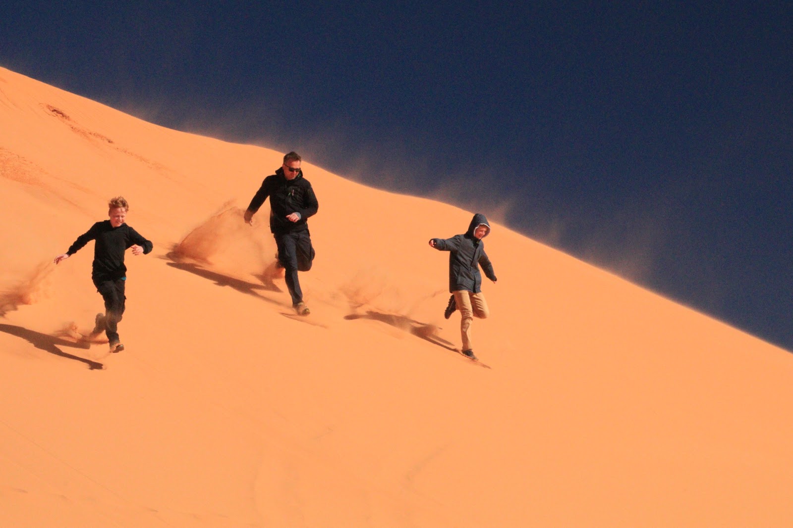
The risk for wet shoes is non-existing in the sand dunes 😏, so we did make a stop there before heading to Bryce Canyon.
Coral Pink Sand Dunes is a small State Park, located off a remote road a few miles West of Kanab. We weren't sure what to expect, but we thought it would be a nice intermezzo for the boys. It turned out to be a perfect stop to get some energy by running, jumping, tumbling around in this 'desert like' place! It was pretty cold and windy, but that did not hold us from enjoying it to the fullest.


The park is named after Ebenezer Bryce, a Scottish man who was disowned by his father for converting to Mormonism, who lived in the area in the 1860s.
The rim of Bryce Canyon is located at an elevation from 8000 up to 9000 feet (2400 to 2700 meter) ... for comparison reasons, the highest point in Belgium is only at 2277 feet (694 meter)!!
We were there at the end of November, and the landscape was partly covered with snow and it was freezing! It only added to the surreal experience Bryce already is!
Bryce Canyon is not actually a canyon but a spectacular series of more than a dozen natural amphitheatres, each of which is carved at least 1000 feet (300m) into the pink Claron limestone of the Paunsaugunt Plateau.
It is home to the largest number of hoodoos in the whole world, which are rock pillars dissolved by erosion into bulbous spires. They typically consist of relatively soft rock (mudstone), topped by harder, less easily eroded stone (dolomite, limestone and siltstone) that protects each column from the elements. Because of the differential erosion of these different rock types, hoodoos have a variable thickness giving them this 'totem-pole shaped body'.
It is home to the largest number of hoodoos in the whole world, which are rock pillars dissolved by erosion into bulbous spires. They typically consist of relatively soft rock (mudstone), topped by harder, less easily eroded stone (dolomite, limestone and siltstone) that protects each column from the elements. Because of the differential erosion of these different rock types, hoodoos have a variable thickness giving them this 'totem-pole shaped body'.


It's no surprise that without this scientific explanation, the Paiute Indians, who occupied the area as from 1200 AD, were inspired in a godly way by this mystic scenery. This is how their legend goes:
The 'Legend People' lived here long before the Indians. These people were animals, lizards and birds who looked human. They lived in a time when the God Coyote oversaw this land. They were bad people as they took more than they needed, used the resources of the land beyond what it could sustain (mmmm, sounds familiar? 😏). Because of this unacceptable behaviour, the mighty God Coyote lured the Legend People to what was supposed to be a celebration banquet, but instead turned them to rocks.
The way the hoodoos are clustered together near the rim, reflects the panic of the Legend People when they realised what was happening to them, and the red of the hoodoos is the paint they were wearing at the time of their transformation.
We arrived in the late afternoon, just in time to get a first taste of the park by taking the scenic road through the park and making short stops at some of its viewpoints.

As all viewpoints are located on the East side, I recommend you drive straight to the 'Rainbow point' at the end of the road and stop at the other viewpoints on your way back.
 |
| Rainbow point |
 |
| Natural bridge |
At our last viewpoint of the day, we enjoyed a gorgeous sunset at ... Sunrise Point 😆,


After this first taste of the park, we checked in in our hotel in Tropic, a little village 10 minutes from Bryce.
'Bryce Canyon Log Cabins' is a really fun place to stay. Although at first sight it didn't look very appealing (1 row of cabins all lined up next to each other), the cabins are really cosy and clean, their is WIFI (which made our kids very happy 😏) and each cabin has a terrace.
'Bryce Canyon Log Cabins' is a really fun place to stay. Although at first sight it didn't look very appealing (1 row of cabins all lined up next to each other), the cabins are really cosy and clean, their is WIFI (which made our kids very happy 😏) and each cabin has a terrace.

We had dinner in 'Bryce Canyon Pines Restaurant', which is 8 minutes from Bryce Canyon National Park and 18 minutes from our charming cabin.
There was a long waiting line and we waited for more than 30 minutes to get a table. It's always hard to rate the restaurants here in this non-culinary country, but let's just say that in an area full of tourist traps and overpriced unhealthy food, it was definitely worth the wait!
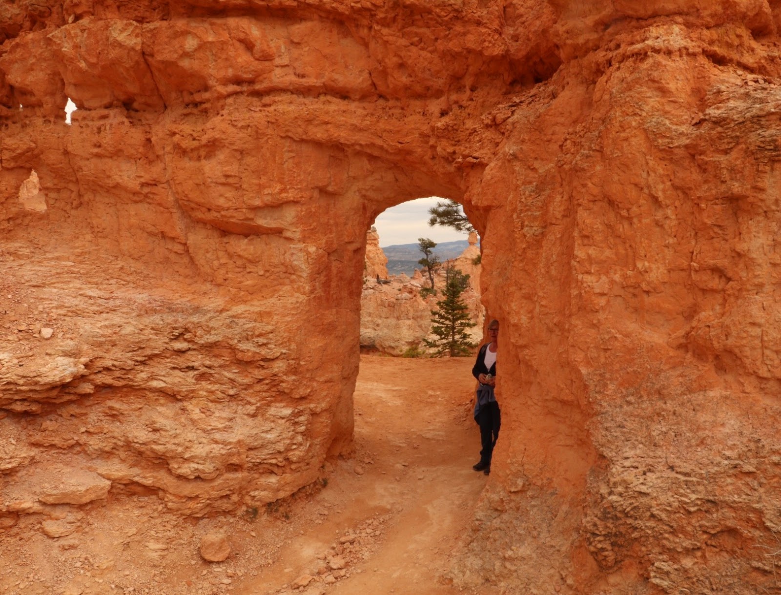
The next day we returned to the park and hiked into the canyon. The views from the top were amazing, but you just need to hike down to see it from the bottom up as it will give you a whole new and, again, great experience!
There are a lot of hikes to choose from, and probably you cannot go wrong with any of them. We did the 'Queens Garden and Navajo Loop Trail', a hike of 4,3km with 190m elevation gain.
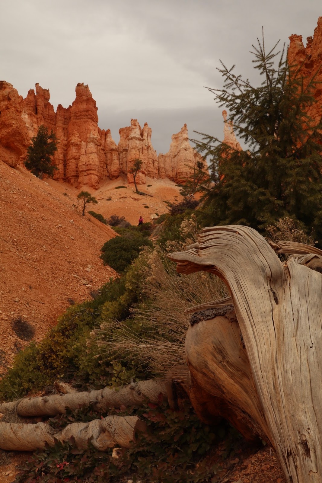
We descended into the canyon at Sunrise point via the Queens Garden trail, which interconnects in the canyon floor with the Navajo loop.


Descending into the canyon via the Queens Garden trail


Views on our way down

The Canyon floor
Our final ascent to Sunset point was via the famous switchbacks, called 'Wall street', on the Navajo Loop.


The hoodoos are so steep and high here and at some parts so close together that, with some fantasy, you indeed could get the feeling walking between natural Wall Street-like skyscrapers.


However here you don't have to fear for falling stocks, but you do have to watch out for falling rocks! 😆
While walking around, I was again surprised how plants seem to be able to grow at the most odd and seemingly impossible places ... while at my place, with all my care and love 😇, they just die?! 😬

Only 2days after we got back home from our trip, we woke up with this view ...

... winter had arrived!


After this hike, we continued with our car and stopped at some of the same view points as we did last time, like 'Rainbow Point' and 'Natural Bridge', but we also stopped at 'Inspiration Point' this time and I'm glad we did. Don't skip this one, the view is absolutely phenomenal!


April 2017
In April 2017 Geert's mom visited us for 2 weeks. As it was her first time in Utah, we had to at least show her some of the National Parks (NPs) in the South, Bryce NP was one of them.
We took the Zion-Mount Carmel Highway, a very scenic route straight through Mount Carmel via some tunnels, to go from Zion (the other NP we visited with her, ref. Zion NP post) to Bryce.
On our way we spotted some little bighorn sheep, who apparently outran their parents (we know how that feels! 😉), and the parents were calling them back from the other side of the road, and we were just right in between ... at least that was our interpretation of the situation😏. It was a beautiful thing to watch them reunited!

The 'lost' little ones

The rest of the family, calling them ...

Reunited
We stayed the night in a no-frills hotel in Panguitch, a small town 25 miles from Bryce Canyon NP, and apparently it has a lot of welcoming rural charm and a strong sense of heritage. But after all the hiking in Zion NP, the energy level was pretty low, and we arrived pretty late at the hotel as we had dinner somewhere along the road ... so do I need to mention that we skipped a visit to the town? 😆
The next morning we headed to Bryce Canyon. This time we did the 'Navajo Loop Trail to Peekaboo Loop', a hike of 7.1km with 411m of elevation gain.

We started and ended via 'Wallstreet', the famous switchbacks at Sunset point which I mentioned before. But that is not the only climb you do during this hike. You go up and down throughout the whole hike which may make the hike pretty strenuous if you're not in great shape, especially as you have to finish it with a last steep climb up Wallstreet at the end. The views however are definitely worth it! If you have the time, I really advice you to do this hike!

View from the starting point

Going down Wallstreet
Along the ... Peekaboo 😉 trail


Our lunch place

Halfway 😅

4 'Gnomes' on their way


Willem just loved touching the red sandstone throughout the whole hike...


... with this beautiful result 😏

Going up via Wallstreet again

Back up at Sunset point.


View at Rainbow Point

In the left you see people standing on Inspiration Point

View from Inspiration Point
After our visit to Bryce Canyon NP, we drove to Tropic and stayed the night in the same cabins as we did in November the year before (Bryce Canyon Log cabins). As I said, It's just a fun little place, with clean and cozy rooms where you can enjoy a beer outside your cabin (not a given in Utah!) while enjoying the view. They don't serve breakfast, but there's a decent place, 'Rustler's Restaurant', across the street.


Bed approved by Ingrid ...

... sofa too 😆. Did we wear her out??


The next morning we returned home, but instead of taking the 'boring' I15, we took the scenic tour via Route 12 which leads you through 'Grand Staircase Escalante National Monument', where one last hike was awaiting us!


Comments
Post a Comment